
Stress tests
In March 2020, just as they were due to begin intensive testing of key components in their deep-sea monitoring system, the Covid-19 pandemic banished Ralf Bachmayer and his team at the Innovation Center for Deep-Sea Environmental Monitoring to their desks.
The year had begun so well. At the end of February 2020, Professor Ralf Bachmayer from the Innovation Center for Deep-Sea Environmental Monitoring and two of his colleagues were ready to test the main technical components in their deep-sea monitoring system: the deep-water robot operated via remote control (ROV, or remotely operated vehicle), the latest model of their customised autonomous underwater vehicle (AUV for short), an optic modem, a low-light camera and—the newest component—the “Bodenknoten”, an autonomous stationary camera system. These instruments are the fruit of two years of research, and this was the first time they would be tested in the ocean. The ROV and AUV are at the centre of the researchers’ strategy to chart the deep sea. The movements of the vehicles must be as gentle as possible to avoid disrupting—and in the worst case permanently damaging—the underwater environs. To ensure eco-friendly operations, Ralf Bachmayer is taking a multipronged approach. Firstly, the small agile AUV records images as it slowly glides over the seabed. It then transmits the image data to the larger ROV located above the AUV at a greater distance from the seabed. The ROV sends this information to the MARUM team aboard a research vessel, providing them with an overall impression of the seabed and the AUV’s location and enabling them to maintain overall control and coordination of the ROV and AUV.
The precious deep sea
The ecosystems in the deep sea are so sensitive that recovery is almost impossible once they have been disrupted. Starting at an ocean depth of 200 metres, all aspects of life—motion, reproduction and regeneration—occur at a very, very slow pace. This means that the plans held by many countries and businesses to mine the seabed for valuable resources (gold, silver, cobalt, manganese and rare earth elements) are nothing short of devastating. Indeed, earlier mining attempts caused serious damage to the highly sensitive deep sea, damage that remains visible decades later. Bachmayer is developing methods and systems to monitor the fragile deep-sea ecosystems—because only when the International Seabed Authority ISA has gathered more exact knowledge of the ecologically valuable areas will it be able to protect these regions and forbid mining operations in them.
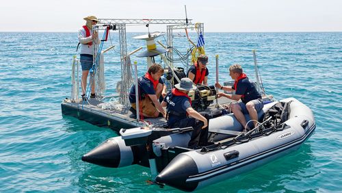
Tests in the Mediterranean
In February 2020, Ralf Bachmayer and his team were in the starting blocks. Stationed in the Mediterranean, the anticipation mounted as they sat in the control room of the research vessel Alkor and tracked the progress of their underwater robots on a monitor. “We switched on the ROV’s light, and the low-light camera on the AUV captured images of roughly 70 square metres of the seabed—with no glitches in the ROV,” says Bachmayer. “The communication between the vehicles worked as we had envisioned it. We were thrilled.” Testing out the Bodenknoten—the autonomous, stationary camera system—was also successful. “We positioned the Bodenknoten on the sea floor of the Mediterranean,” says Ralf Bachmayer. “The system looked around and autonomously detected the light source—from the ROV in this case—and then took pictures despite poor visibility, just as we had planned. The system sent the images via the wireless optic modem up to the ROV.” In future, the Bodenknoten will be used to take measurements and capture images of the seabed, either individual photographs or as a series. The data recorded can be retrieved via the wireless optic modem. The final station before the lockdown was an observatory off the Spanish coast. These observatories are stationary measuring stations, used to gauge various parameters, including pressure or the temperature profile of the sea floor. Observatories can also store data, including image data, which can be retrieved wirelessly; as such, researchers can use the observatory as temporary storage for image data while charting the seabed.
A rude interruption
The coronavirus pandemic arose just as the tests on equipment in the Mediterranean were drawing to a close, thwarting any chances of quickly developing the components any further. “In a worst-case scenario, we can test our components in bodies of water that are close to Bremen—the Weser or the North Sea, for instance,” Bachmayer said during the summer, after the lockdown restrictions had been lifted. “The North Sea is only 40 metres deep compared to the 200 metres in the deep sea, but we could at least test the AUV’s navigation system in conditions of poor visibility.” Ralf Bachmayer would naturally like to realise all the plans he had laid for 2020. “The pressure is on, but we researchers are setting the fast pace, not our employers,” he says, adding, “which can sometimes make it harder.” Can the team overcome the additional obstacles created by the novel corona-virus in addition to mastering the challenges posed by the deep sea itself? “We’ll get it done,” says Bachmayer. “But it’s essential that we take a step-by-step approach to realising our deep-sea monitoring strategy. The many technical and scientific challenges might otherwise be overwhelming.”
Text: Brigitt Blöchlinger
Photo: MARUM – Center for Marine Environmental Sciences at the University of Bremen


 are dependent on expensive “mother ships”—in future, they will be joined by independent marine vehicles with long-term autonomy.")